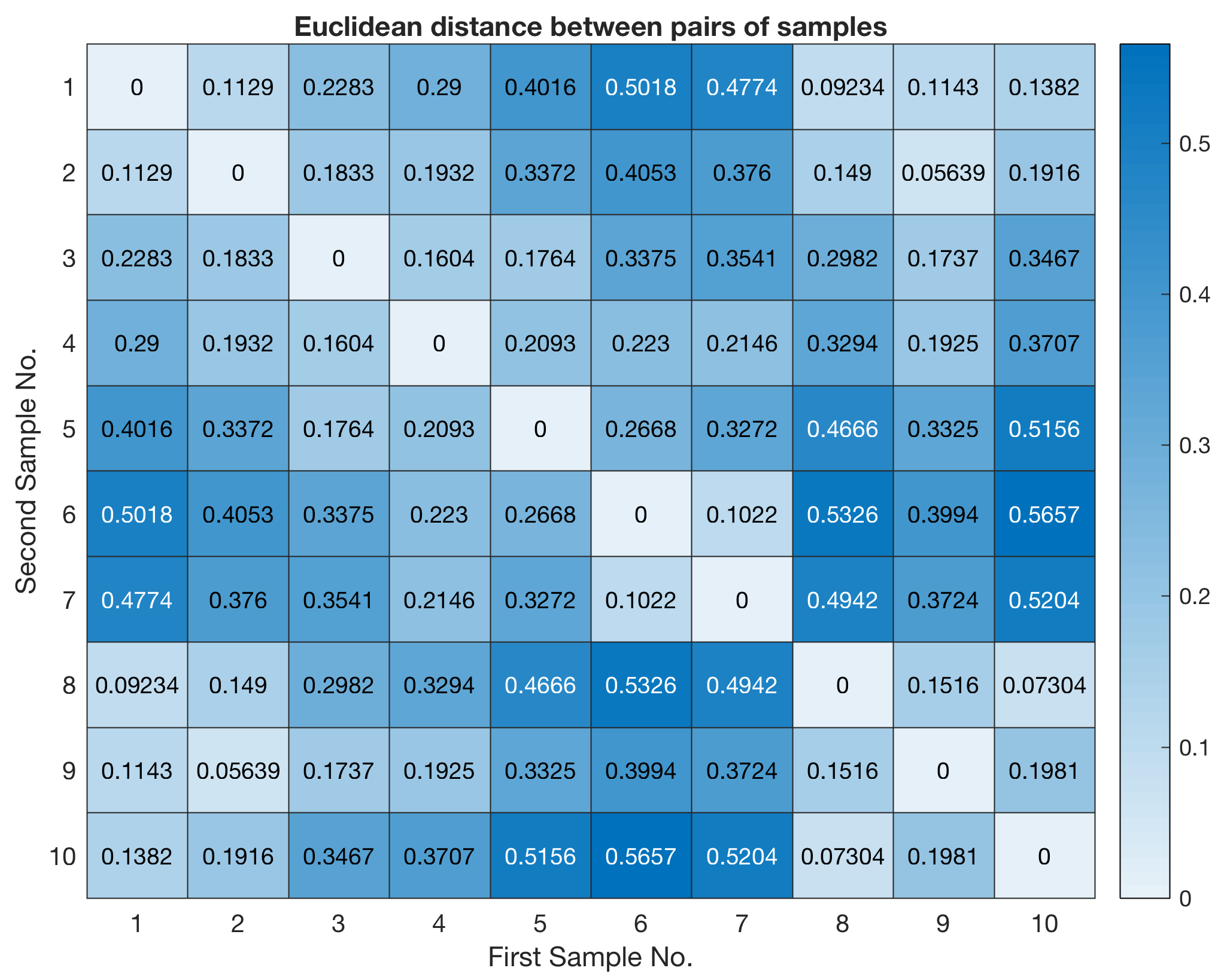
Thanks to the great support of MathWorks sponsoring the curriculum development of the new MATLAB/LEGO MINDSTORMS Environmental Remote Sensing Lab we just received eight more boxes of LEGO MINDSTORMS. Together with various devices to acquire typical multispectral, geophysical and geometric data, we cannot wait to use it to teach how geoscientific data is collected, processed and analyzed on the scale of a laboratory. The progress of course development as well as course materials will be provided on this blog.
Reproducing the Results of hist by the More Recent Function histogram of MATLAB
With release R2014b the new function histogram was introduced to replace the old function hist. Here is a script to reproduce the result of hist by the new function histogram. Continue reading “Reproducing the Results of hist by the More Recent Function histogram of MATLAB”
42nd Shortcourse On MRES
Next week the 42nd shortcourse on MATLAB Recipes for Earth Sciences will begin with 34 participants from 10 different research institutions and universities. It is the second of the two spring courses at the University of Potsdam. Continue reading “42nd Shortcourse On MRES”
Image Stitching with MATLAB
The exercise on image stitching with MATLAB is intended to help students to understand how to merge multiple images taken with a webcam using MATLAB. We used a webcam, mounted on a four-wheeled LEGO vehicle on rails with a single large motor, controlled with MATLAB, to acquire, process and merge multiple images.
Continue reading “Image Stitching with MATLAB”
MATLAB/LEGO MINDSTORMS Exercise #8 Image Stitching with MATLAB
Calculating the NDVI From Multispectral Camera Images Using MATLAB, Part 1
This exercise is intended to help students to understand how to capture NDVI Red+NIR images using a MAPIR Survey2 NDVI Red+NIR camera, to import the images into MATLAB and to calculate the Normalized Difference Vegetation Index. Continue reading “Calculating the NDVI From Multispectral Camera Images Using MATLAB, Part 1”
MRES Exercise #5 Calculating the NDVI From Images Using MATLAB
Importing and Processing EO-1 Hyperion Images with MATLAB
The journey of NASA’s EO-1 satellite is coming to an end. The images recorded by the Hyperion Sensor, aboard the satellite, during the past years, will provide valuable information about the Earth’s surface for many years to come. Continue reading “Importing and Processing EO-1 Hyperion Images with MATLAB”